Description
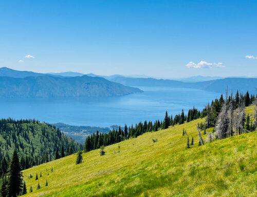
Stunning views of Lake Pend Oreille, the Cabinet Mountains, and the Selkirk Mountains await you on top of Bonner County’s tallest peak. Hikers will likely find company at the top, where mountain goats negotiate rock outcroppings and steep cliffs.
From the trailhead, the route begins relentlessly uphill for the first mile until reaching the first set of switchbacks. At that point, the grade becomes more bearable. About two-thirds of the way up, the trail passes through a large hillside meadow, with stunning views of Lake Pend Orielle and the Clark Fork River Valley. The trail eventually intercepts the ridge and follows it to the summit. Follow cairns and other indicators through the talus.
The Scotchman Peaks are inhabited by grizzly bears and mountain goats. Hikers are advised to take special precautions to reduce the risk of negative bear encounters. Please do not feed the mountain goats or any other wild animals. Feeding wild animals may result in serious injury or death.
Distance
3.5 miles (one way)
Elevation Gain
3,700 feet
Directions
Take Highway 200 (east from Sandpoint) and in downtown Clark Fork turn north at the Chevron Station. Go past the school and continue up Mosquito Creek Road #276. Go past the (former) Clark Fork Field Campus to the junction of Road #2294. Turn right and go a little over a mile. Watch for signs for trail #65. Turn left on road 2294A. Follow this road a little over a mile to where it ends at the trailhead.
Maps
Forest Service: Kaniksu National Forest
USGS Quad(s): Clark Fork NE
Maintenance Report
No information.
Land Status
The Scotchman Peaks are a proposed wilderness area.
Guidebooks
100 Hikes in the Inland Northwest by Rich Landers (2nd Edition, 2003)
Trails of the Wild Cabinets By Dennis Nicholls with Jim Mellen (2nd Edition, 2008)
Leave A Comment